Altitude angel launch all-new drone assist app
Altitude Angel, the world’s most trusted UTM (Unified Traffic Management) technology provider, is to release a new and improved version of the UK’s most popular flight planning tool, Drone Assist, bringing a host of new features which will give users an even greater understanding of the sky above them and access to it.
Already established as the flight planning app for professional and recreational drone pilots alike, the updated Drone Assist is the foundation stone on which the UK can build a £40billion drone economy, now features direct connection to Altitude Angel’s UTM platform, offering ‘one-tap flight authorisations’ at connected airports and facilities worldwide.
Over the coming months, this new Drone Assist will replace all the company’s existing apps and serve as an important initial gateway to a whole host of U-Space services offered by Altitude Angel and operated by its customers.
“All commercial drone operations start with a plan, and planning should start with Drone Assist, which is why we’ve invested so much in creating an app which can truly enable safe drone flight anywhere,” said Richard Parker, Altitude Angel, CEO and founder.
The new version of Drone Assist, which begins rolling out from Monday, 22 May for both iOS and Android, is the most extensive update since the app was first launched in 2016 and includes the first in a series of planned enhancements and exciting new features.
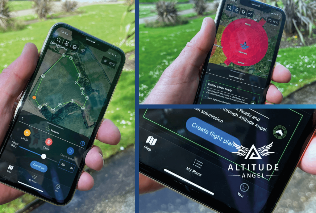
The suite of new features includes enhanced integrated flight planning, advanced flight plan drawing tools, and approval services – the ability to request access to fly digitally in airspace such as an airport FRZ, or land with access restrictions – through the app.
These updates make the app more user-friendly and intuitive for novice pilots, whilst providing several business-critical services for more experienced and professional operators.
The new Drone Assist has been developed in conjunction with the drone community, which included a beta testing programme with over 400 active contributors, the feedback from which was incorporated into the app’s design and build. As one example, the users asked for enhanced flight planning features to be lifted and prioritised. Drone Assist now allows users to plan their flight, detailing exactly where they will be flying using the advanced drawing tools using polygons or waypoints – and submit the plan to the app – with the flight then displayed not only on the app for all to see, but across all of Altitude Angel’s UTM platforms, including those used by airports and GA pilots – making other airspace users aware of their presence.
In addition to enhanced integrated flight planning & drawing tools, Drone Assist also includes new ‘pilot profiles’ and aircraft management, which provides users with the ability to log drone operator profiles, hours flown, and airframe hours used. These features are particularly useful for professional drone operators who may be required to manage or evidence their operational experience and help in managing airframe service intervals and the like.
Other upgrades and new features also include:
- New map layers including satellite view.
- Enhanced airspace filter controls.
- Refreshed user experience and user interface.
On the re-launch of Drone Assist, Richard added: “We’ve seen through the user numbers, which have increased year-on-year, pilots and operators love Drone Assist. Having brought the app back in-house, we knew what needed to be done to make Drone Assist what we, and its users, whether recreational, commercial, or public safety, really wanted. So, after much design, development, and beta testing, we’re excited and proud to be releasing this updated version.
“Now, with the new Drone Assist out there, we have a platform on which drone operators can begin to build businesses and realise the potential of drones, building an industry to change the world. And this is just the first in a series of new-feature releases we’ll be making as we continue to bring new services and opportunities to airspace users, managers, and landowners across the country and beyond.”
For more information, download the app, or visit our microsite here to see what’s next.